In alcune pagine web russe è stata pubblicata una notizia "sconvolgente": un ricercatore dell'Università del Bashkir avrebbe scoperto una lastra di pietra su cui è incisa una mappa della regione degli Urali come appariva 120.000.000 di anni fa.
La notizia, sulla quale si sono scatenate discussioni anche nel newsgroup it.discussioni.misteri, è poi stata ripresa anche in Italia:
Secondo queste fonti la "mappa" sarebbe stata esaminata dall'Istututo di Cartografia del Wisconsin che avrebbe poi rilasciato dichiarazioni a dir poco sconcertanti. Secondo i giornalisti russi infatti gli studiosi americani avrebbero dichiarato che la "mappa" sarebbe il risultato inequivocabile di esplorazioni condotte dall'alto, quindi realizzate a partire da riprese aeree o da satelliti:
"Original estimates put the slab's age at 3,000 years, but when the shells encrusted into the map were found, it was assumed that the slab was much, much older.The most intriguing part of it all is why the map was created in the first place. When the center of historical cartography in Wisconsin looked at the map, the Americans pronounced their verdict: a three-dimensional map could only be used for navigational purposes. It could only be made using of aerospace photography. As a matter of fact, work is under way in the United States to create a three-dimensional map of the world; the project is expected to be completed only in 2010, given that the Americans will have to process an enormous mass of numbers"
"What could be the destination of the map? That is probably the most interesting thing. Materials of the Bashkir find were already investigated in Centre of Historical Cartography in Visconsin, USA. The Americans were amazed. According to them, such three-dimensional map could have only one destination  a navigational one, while it could be worked out only through aerospace survey. Moreover, namely now in the US, work is being carried out at creation of world three-dimensional map like that. Though, the Americans intend to complete the work only to 2010. "
"Workers of the Wisconsin Center of Historical Cartography (USA) are stricken: according to the Americans, the 3-D map had a navigation destination, while it could be produced only as a result of an aerospace survey."
Ho voluto verificare questa notizia, che già pareva sospetta in quanto apparsa per la prima volta in data 1 aprile 2002, così ho scritto al rettore dell'Università del Bashkir, chiedendo informazioni a proposito di Alexander Chuvyrov, il docente che avrebbe fatto la scoperta. Non ho ricevuto nessuna risposta.
Allora ho scritto al Direttore dell'unico istituto di cartografia esistente in Wisconsin, "The History of Cartography Project".
http://feature.geography.wisc.edu/histcart/
E da lui ho avuto la prima risposta:
Quindi è chiaro che quell'istituto (ci tengono a dire che è l'unico che si occupa di cartografia in Wisconsin) non ha mai rilasciato quelle mirabolanti dichiarazioni e il Prof. Chuvyrov non avrebbe autorizzato la pubblicazione di quegli articoli apparsi in Russia.
Allora ho pensato di scrivere direttamente a Chuvyrov, il cui indirizzo e-mail mi era stato fornito proprio dal direttore dell"istituto di Storia della Cartografia del Wisconsin.
Dopo un mese ho ricevuto una prima risposta da Chuvyrov.
Gli ho scritto ringraziando e chiedendo se potevo renderre pubblico il suo messaggio, e soprattutto se potevo avere delle foto della lastra di pietra, visto che le uniche due visibili in una pagina web erano molto piccole e sfocate.
Dopo pochi giorni ho ricevuto tre foto in formato JPG senza nessun accenno a proposito della pobblicazione della sua risposta. Forse anche in Russia vale la regola del silenzio-assenso, così ritengo di non commettere nessuna violazione alla privacy pubblicando la sua breve risposta:
Purtroppo l'inglese di Chuvyrov non è migliore del mio, imparato a scuola, così certe parti del messaggio risultano poco chiare.
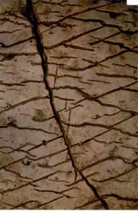
Quello che invece mi pare chiaro guardando le foto è che quella lastra di pietra non è altro che... una lastra di pietra con molte crepe, dall'aspetto naturale, non artificiale. L'effetto è quello di un "craquelé" con le rotture in due direzioni principali, non ortogonali tra loro.
Il vero mistero a questo punto è come qualcuno possa sostenere che quelle incisioni rappresentino strade, canali, aereoporti, come si legge nelle pagine web già citate.
Diego Cuoghi
20 luglio 2002
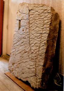
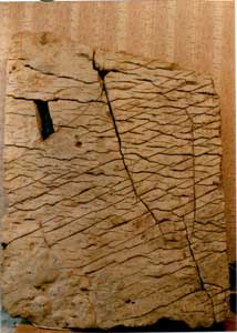
Le fotografie sono di proprietà di Alexander Chuvyrov.
Altre pagine di Diego Cuoghi :
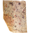
mappa di Piri Reis
- http://www.itogi.ru/paper2002.nsf...
- http://www.therussianissues.com/...
- http://english.pravda.ru/main/2002/...
- http://english.pravda.ru/main/2002/...
La notizia, sulla quale si sono scatenate discussioni anche nel newsgroup it.discussioni.misteri, è poi stata ripresa anche in Italia:
- http://www.giornaletecnologico.it/scienza/...
- http://www.irc.it/article.php?sid=1438
- http://digilander.libero.it/eureka82/misteri.htm
Secondo queste fonti la "mappa" sarebbe stata esaminata dall'Istututo di Cartografia del Wisconsin che avrebbe poi rilasciato dichiarazioni a dir poco sconcertanti. Secondo i giornalisti russi infatti gli studiosi americani avrebbero dichiarato che la "mappa" sarebbe il risultato inequivocabile di esplorazioni condotte dall'alto, quindi realizzate a partire da riprese aeree o da satelliti:
"Original estimates put the slab's age at 3,000 years, but when the shells encrusted into the map were found, it was assumed that the slab was much, much older.The most intriguing part of it all is why the map was created in the first place. When the center of historical cartography in Wisconsin looked at the map, the Americans pronounced their verdict: a three-dimensional map could only be used for navigational purposes. It could only be made using of aerospace photography. As a matter of fact, work is under way in the United States to create a three-dimensional map of the world; the project is expected to be completed only in 2010, given that the Americans will have to process an enormous mass of numbers"
"What could be the destination of the map? That is probably the most interesting thing. Materials of the Bashkir find were already investigated in Centre of Historical Cartography in Visconsin, USA. The Americans were amazed. According to them, such three-dimensional map could have only one destination  a navigational one, while it could be worked out only through aerospace survey. Moreover, namely now in the US, work is being carried out at creation of world three-dimensional map like that. Though, the Americans intend to complete the work only to 2010. "
"Workers of the Wisconsin Center of Historical Cartography (USA) are stricken: according to the Americans, the 3-D map had a navigation destination, while it could be produced only as a result of an aerospace survey."
Ho voluto verificare questa notizia, che già pareva sospetta in quanto apparsa per la prima volta in data 1 aprile 2002, così ho scritto al rettore dell'Università del Bashkir, chiedendo informazioni a proposito di Alexander Chuvyrov, il docente che avrebbe fatto la scoperta. Non ho ricevuto nessuna risposta.
Allora ho scritto al Direttore dell'unico istituto di cartografia esistente in Wisconsin, "The History of Cartography Project".
http://feature.geography.wisc.edu/histcart/
E da lui ho avuto la prima risposta:
Statement from the History of Cartography Project:
1. The History of Cartography Project is not the "Centre for Historical Cartography in Wisconsin" cited in the Pravda article.
2. We do not know of any such center in Wisconsin.
3. Nobody in America known to us has seen the original map and we believe that no-one who has not seen the original should comment on it.
4. Professor Chuvyrov was in touch with us two years ago about this map, and we said then that we could not comment on the map without seeing it and the evidence for its authenticity
5. Professor Chuvyrov told us recently that he did not authorize the article appearing in Pravda.
Quindi è chiaro che quell'istituto (ci tengono a dire che è l'unico che si occupa di cartografia in Wisconsin) non ha mai rilasciato quelle mirabolanti dichiarazioni e il Prof. Chuvyrov non avrebbe autorizzato la pubblicazione di quegli articoli apparsi in Russia.
Allora ho pensato di scrivere direttamente a Chuvyrov, il cui indirizzo e-mail mi era stato fornito proprio dal direttore dell"istituto di Storia della Cartografia del Wisconsin.
Dopo un mese ho ricevuto una prima risposta da Chuvyrov.
Gli ho scritto ringraziando e chiedendo se potevo renderre pubblico il suo messaggio, e soprattutto se potevo avere delle foto della lastra di pietra, visto che le uniche due visibili in una pagina web erano molto piccole e sfocate.
Dopo pochi giorni ho ricevuto tre foto in formato JPG senza nessun accenno a proposito della pobblicazione della sua risposta. Forse anche in Russia vale la regola del silenzio-assenso, così ritengo di non commettere nessuna violazione alla privacy pubblicando la sua breve risposta:
I am not responsible for journalists words. They are often said such thing to catch a sensation. My task was much more modest. It is concluded in investigation of discovered object, its structure, inscriptions etc. Today we may say the following:
1 The existance of the object is a fact. This fact was unexpected for all. I for a long time considered that this just a picture, where some terrain is shown, more exactly type on it from the heights.
2. Today this object is exposed in the museum of archeology and everybody can get acquainted with it. Amongst the people it is considered by the magic stone, stone of god.
3. Different explanations of picture, hewed on the stone are exist. The main one is a suggestion that local tribes of antiquity did it with the help of axe Such standpoint must be considered either.
4 Paleogeology of theTerrain, which is shown on the stove sufficiently well studied, so it is possible to say with the big degree of confidence about the age of scenes. The terrain which is shown on the stown stove, dated more than 20-30 million years back
I once again emphasize that can be a scene is inflicted 100 thousand years back, but corresponds it exactly specified age. To Guess, who this has done, is not my problem. This must do sufficiently competent international commission.
Purtroppo l'inglese di Chuvyrov non è migliore del mio, imparato a scuola, così certe parti del messaggio risultano poco chiare.
Quello che invece mi pare chiaro guardando le foto è che quella lastra di pietra non è altro che... una lastra di pietra con molte crepe, dall'aspetto naturale, non artificiale. L'effetto è quello di un "craquelé" con le rotture in due direzioni principali, non ortogonali tra loro.
Il vero mistero a questo punto è come qualcuno possa sostenere che quelle incisioni rappresentino strade, canali, aereoporti, come si legge nelle pagine web già citate.
Diego Cuoghi
20 luglio 2002
Le fotografie sono di proprietà di Alexander Chuvyrov.
Altre pagine di Diego Cuoghi :
mappa di Piri Reis